Hawaii’s Big Island: Waipio Valley, Wise Old Grandmothers, Tsunamis, and Kapus

The man on the ATV waved and smiled as our tourist van lurched by on the rutted red mud road. I smiled at his friendliness, but stopped before I waved back – since his ‘wave’ had turned into a one-finger salute.
Not so friendly then, these Valley residents, just as the tour books warned.

And I understand, I do, especially the part our guide Douglas shared, about how buzzing helicopters hover in the sky so tourists can snap shots of the Valley’s cascading waterfalls, precisely at the same time each day – he sets his watch by it, he noted with resignation.
Since the residents who choose to live off the grid here do so to escape modern life, they might very well feel like small fish trapped in a stunning green fishbowl when the flying metal birds and tourist vans arrive. I can almost understand why the ATV man made a rude gesture to perfect strangers. Almost.

At least the fishbowl didn’t fill up when we forded several streams on the valley floor. The entire valley did that in 1946 when a deadly tsunami surged in, sweeping a classroom of students and three teachers in the nearby town of Laupahoehoeto to their tragic deaths.
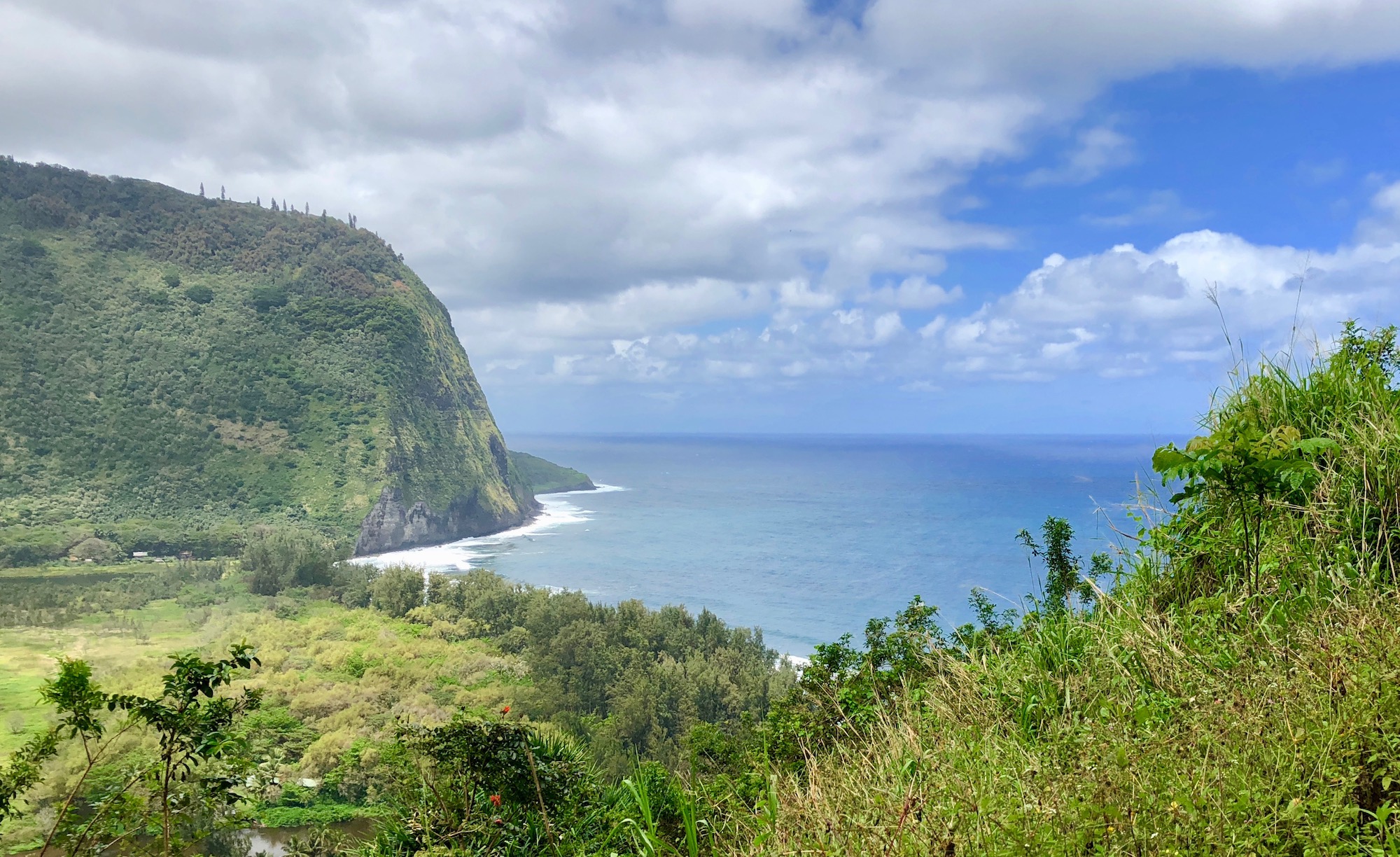
One of the most picturesque natural settings in the entire world, Waipio Valley sheltered a robust ancient Hawaiian civilization before 1778, when Captain Cook and his scalawags arrived. Cook and his crew spread disease, munitions, liquor, and a tidal wave of other deadly stuff everywhere they landed. The cultural method of destruction took a bit longer, but the ‘gifts’ of the scalawags emptied out this valley far more effectively than any old tsunami ever did. Today, about 50 people live in the valley, while upwards of 10,000 Hawaiians once prospered here.

And since it’s still relatively untouched (except for those pesky helicopters and tourist vans), we could easily imagine what it might have looked like when the ancients lived here – probably pretty much the same as it does today. Lush vegetation sheltered under a dense canopy of wild green, rich red soil, and a black sand beach so perfect that it is regularly featured in movies (think that terrible movie Waterworld, for one).

We’ve been immersed in Hawaiian history the past few days. History fiends that we are, we love museums, but the best part about the Big Island’s museums? Most of them are open-air. We can get our history fix while traversing a volcano (the Big Island has five of them, not just the famous misbehaving one). Or trek parts of the Ala Kahakai Trail, a 175-mile corridor of historic sites and settlement ruins. The trail is not contiguous yet, but Hawaii’s working on that (kind of like the vast resort location we passed, which has been ‘in development’ for 30 years…..but we can hope!).


We hiked a few miles of The Ala Kahakia Trail to see ancient petroglyphs, fish ponds, ruins of ancient temples, and to clomp through old lava flows (wear sturdy shoes). You also can hike all the way out to Waipio’s black sand beach, which we didn’t do this time; the hikers we drove by looked sweaty and weren’t smiling. It’s a long, hot, insect-plagued journey through all the mud and vegetation, Douglas told us – one mile down and ten loooong miles back up. And you’d have to watch out for a red-and-black ATV, with that unfriendly local at the wheel.

The locals seemed to like Douglas (just not us, I’m guessing), a native Hawaiian who’s lived all his life nearby, and he didn’t say a word the first few minutes into the drive down the cliff road. But then he spoke in a slow, measured Hawaiian voice, delivering carefully crafted cultural and history tidbits, communicating his deep reverence for his beloved valley. He shared many tales passed down to him by his wise Waipio Valley grandmother, continuing the oral tradition that brought the valley’s spiritual and cultural values into sharp relief. Fascinating.

Waipio Valley Shuttle Tours is a locally-run tour outfit housed in Waipio Valley Artworks, which features local artist’s creations and is by itself worth the long drive to the town of Kukuihale from Kona or Hilo. You can also tour the valley by horseback or horse drawn wagon, or hike it, of course. Any way you get down into the valley, I say do it – one of the most amazing places we’ve visited in the travels thus far. (And if you must swoop in by helicopter, at least feel a bit sheepish about disturbing the locals with the tourist gawking, like we did.) And don’t worry if it rains. It usually does, and the misty, sometimes torrential rain brings the valley alive with waterfalls, running streams, reflecting pools, and dripping trees in every shade of green.


Our favorite national park turned out to be Kalako-Honokohau, where we hiked along petroglyph trails to a stunning beach and coastline trail. Since all oceanfront is public land in Hawaii (at least the first 30 feet of shoreline is) we also strolled along the edge of golf courses and beaches in front of exclusive lodgings like the Fairmont Orchid. That hotel is gated at the entrance, but hey – we just skipped down the road awhile, parked in the public lot, and voila! We followed the trail to the beach and enjoyed the same view the Fairmont guests with deep pockets do. Should have brought my cool new portable chair, which I left at home so I could take more shoes for formal nights on the cruise. Padre would rather I brought the chair, since he’s not a big fan of formal nights. Ties and all that, but he deals.
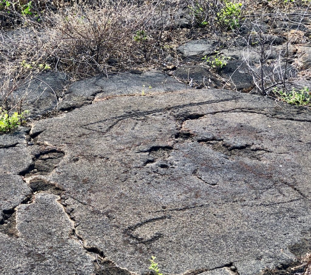
The most memorable petroglyph we saw (there are probably thousands, scattered all over the Big Island), was of a musket rifle. Dated to the late 1770s, it was created just after Captain Cook visited and the native Hawaiians saw their first ‘thunder stick’. Quite the powerful symbol, etched permanently in the lava rock for 300+ years.
The musket art symbolizes the start of all sorts of trouble – not just for Cook, who was killed by the Hawaiians, but for Hawaii’s native population, of course. Since the images and the stories they tell are carved in stone, they’ll last far longer than temporary humans like us –why we ever think we’re more important than a rock etching I just don’t know. But being humbled by history is ok by me.

And I have to mention Kapu, which has always been a favorite word of mine, because my first kitty was named Kapu. Kapu was a powerful concept in Hawaiian culture – a system of prohibitions and punishments that governed daily life and resulted in more than a few untimely deaths due to kapu’s rules involving human sacrifices.
So why was that my cat’s name? In the 1960s my mother visited Hawaii and fell in love with the place. She wanted to bring some part of Hawaii home with her, so she named our kitty Kapu, with the justification that she wanted the cat to keep out –kapu – of cat fights.

Small chance. That cat was a scrapper – probably worshiped the war god Ku, not the peace and abundant harvest god Lono. She always seemed so pleased when she dropped a fat dead mouse on the back porch. A bit ancient Hawaiian, that cat, I suppose – some ritualistic sacrificial elements to her killing work. Quite the bird and rodent killer, who broke our family kapus right and left (stop killing birds, Kapu!). She probably would have been sacrificed or thrown to the sharks to appease the gods posthaste, I’m figuring.
While we were soaking up Hawaiian history, we were also checking out areas for future travel visits. We really liked the area around Mauna Lani, mid-Kohala coast. Definitely more upscale than where we stayed south of Kona, but easy access to historical beach trails and beaches, wide-open walking roads everywhere, and a trendy shopping village that hosts regular musical events like jazz concerts. We might come back and try that next time, but we also know, based on our first experience, that the entire Kona Coast area is going to be more than ok for any future visits we make.

We loved Hawi, for instance, a remote town far from the Kona Coast and closer to Waimea. It’s located on the far tip of the Big Island, where we drove to see Kamehameha’s statue. It’s cooler than the coast, but we wandered through delightful art galleries and spotted several trendy-looking restaurants. Padre perked up when he saw a group of old duffers playing softball at the local park. We also peeked into the community center, where ladies were taking hula lessons. I think we could get into the lifestyle here, even though it’s not on the Kona Coast – I mean, what’s not to like about softball and hula? And old duffers?

Now, we’re off Down Under – first stop Tasmania – where we’ll eventually board the Golden Princess in Sydney for our 30-day cruise back to the States. But we’re not finished with the Big Island this year, not yet: We return in about a month, since our ship sails into Hilo on the way back, when we’ll tour the misbehaving volcano for our first time.
So our Big Island visit was a three-fer: 1) We broke up a long flight (hate those); 2) we saved a bundle because we flew to Sydney on the discount airline Jetstar, and 3) we found a new warm place to hang out in the winter. Yay!


Now we’ll see if we can find a Tasmanian Devil or two, or maybe a kangaroo, or a wallaby – who knows? When we asked our rental car agent for driving advice, the first thing he said was, “Watch out for the wildlife.” (Although our new Hobart friends tell us that’s not necessarily true. Helps to have wonderful new Tasmanian friends – more on that in our next post.) Let’s hope Padre doesn’t take out any Australian critters with our tiny Suzuki – or, more likely, they take out us.
And Padre, remember…..THINK LEFT.
Aloha and thanks, as always, for following along, everyone!